Navigation Blunder
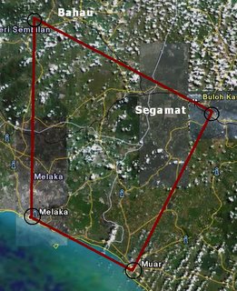
I was a student from Malacca's flying school previously. The training there required me to carry out navigation exercises. Flying from Malacca to Johor or Subang while locating several ulu ulu kampungs and towns. I was to do my Navigation 6 exercise, previously on Navigation 1-4, was an exercise to fly from Malacca to Johor via the coastline, which was pretty simple. Navigation 5 was flown with my instructor going inland and Navigation 6 was my first solo flight (without an instructor) going inland. My mission was to locate Bahau, Segamat, Muar and back to Malacca.
-----------------------------------------TOP SECRET---------------------------------------- Smuggy, we need your help!
Callsign: Academy 436 (every student is given a callsign to be identified while in the air)
Route: Malacca ---> Bahau ---> Segamat ---> Muar ---> Malacca
Mission:
1.) Bomb Bahau
2.) Spy on Enemy's Base in Segamat
3.) Escape through Muar to avoid being located by enemy and head back to base.
Flight Profile:
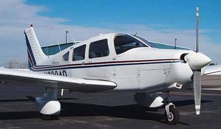
And your ride is a Piper Warrior single engine aircraft which is twice your age:

GOOD LUCK! This message will self destruct
in 5 seconds....
------------------------------------------------------------------------------------------------
Just before my flight, I went to make a phone call to check the weather of the vicinity I was flying in. I went to the outdoor looked up into the sky to check the clouds. Stick my index finger into my mouth and then I pointed it up to the sky. It was a bit cloudy and there is slight wind blowing from the North. I returned back to the Navigation Room to complete my flight plan after obtaining the weather. The flight plan includes distance, time, heading, and fuel calculations. After completing the flight plan I went to get my flight authorized by an instructor by showing them the preparation that I have done. After getting my flight signed off, now I had to wait for the airplane to get back.
slut!
The aircraft is back, its time to make some noise! I took off from Malacca airport and headed north for Bahau. There are a few methods of locating a waypoint.
1.) Fly a constant heading for an amount of time will bring me approximately at that area.
2.) Fly according to the map by looking at ground features, example: terrain, town, road, river and railway then compare it with the map.
3.) Use navigation aids from nearby airports to locate a waypoint with directions and distance away from the airport and fly according to the instrument panel on the aircraft.
I tried using method 1 and 2 to locate Bahau but I couldn't so I had to resort to method 3. BAH BOOM! mission accomplished. I turned right and headed to Segamat. It was quite a long leg to fly from Bahau to Segamat, I could not maintain a constant heading due to clouds. 20 minutes was almost up, I estimated to arrive at Segamat after 20 minutes but the ground features do not match with the map. Shit, so the genius turned left and right and confused himself. I lost my bearings completely, I wasn't sure where the coast was... if I was able to track to the coast, I could have returned to Malacca easily.
I was starting to worry, I threw the map behind and contacted the control tower for assistance.
Academy 436: Lumpur Info, I am currently unsure of postion, request radar vector to Segamat.
Lumpur Info: Academy 436, request your current position.
Academy 436: I am currently lost, request directions to Segamat.
Lumpur Info: We do not have you on radar fly heading 270 and track for the coast.
Academy 436: Copied.
I flew West for quite some time. Then there was a range of mountains blocking my path, shit. They were at least 4000ft high and I was flying at 2000ft. Fuck all matters, I climbed to 6000ft cowboy style. I could not see the peak of some of the mountains because they were covered with clouds. It was unusual for an aircraft of this capability to fly that high. Who cares, nobody knows! it was an emergency anyway. Not long after I cleared the mountains I was able to see the coast. Looking at the map, I was surprised to find that I was around Port Dickson. There was this place called Cape Ricardo that I was able to identify because I've flown over it before.
I told the tower that I've found my way and I'm heading back to Malacca, proudly. When I landed my friends were waiting for me, they knew what had happened and had a laugh. Apparently the directions given by the tower wasn't accurate. I had to explain to the instructors where I went and how I got lost. While I was up there, I was so panic I wanted to land on to the highway. Thank goodness I didn't. The fuss lasted about 2 weeks. There was a new ruling implemented on the flying school. Whoever gets lost will be grounded for a week. Sorry guys.. ahhaaha.. but I got away with that.
A year has passed since this incident had happen. I graduated from the flying school and I went to report back to my company in Subang. They had a 2 week induction period, one of the activities included visiting the control tower in Subang. While visiting, one of my batchmate had an itchy mouth... "Sir, do you know anyone that got lost while flying? and have you heard of Academy 436?" then the guy that was giving us the talk said "It was that girl who got lost right from Malacca?" he also said that they made a report about my incident and saved it in their archive. "That Academy 436 almost made us activate the Search and Rescue". My batchmate then pointed at me.... "Sir, he is Academy 436!!" what good friends I have.


4 Comments:
At 1:31 PM, Anonymous said…
== MiSSion FailED ==
Capt K Shaft nearly send aiR force pilot CapTaIn 434, and his Wingman Copilot 433 to Search For you. Pls be grateful to this two men.
=)
At 2:13 PM, Anonymous said…
ahahaha... yeah.. there was this airforce guy tell me to relax summore
At 8:45 PM, Anonymous said…
can upload pictures already. my korkor so smart!
At 1:24 PM, Anonymous said…
impressive, u are a pilot !
Post a Comment
<< Home